


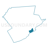
STROUD TWP DIST 07, Monroe County, Pennsylvania
About
Outline

Summary
| Unique Area Identifier | 661249 |
| Name | STROUD TWP DIST 07 |
| County | Monroe County |
| State | Pennsylvania |
| Area (square miles) | 7.22 |
| Land Area (square miles) | 7.18 |
| Water Area (square miles) | 0.03 |
| % of Land Area | 99.55 |
| % of Water Area | 0.45 |
| Latitude of the Internal Point | 40.96059780 |
| Longtitude of the Internal Point | -75.18081200 |
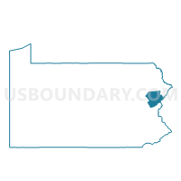
Maps

Graphs
Select a template below for downloading or customizing gragh for STROUD TWP DIST 07, Monroe County, Pennsylvania


Neighbors
Neighoring Voting District (by Name) Neighboring Voting District on the Map
- EAST STROUDSBURG DIST 01, Monroe County, PA
- HAMILTON TWP VTD SOUTH, Monroe County, PA
- SMITHFIELD TWP DIST 03, Monroe County, PA
- STROUD TWP DIST 06, Monroe County, PA
- STROUDSBURG WD 05, Monroe County, PA
- UPPER MT. BETHEL TWP VTD NORTH BANGOR, Northampton County, PA
- UPPER MT. BETHEL TWP VTD SLATEFORD, Northampton County, PA
Top 10 Neighboring County Subdivision (by Population) Neighboring County Subdivision on the Map
- Stroud township, Monroe County, PA (19,213)
- East Stroudsburg borough, Monroe County, PA (9,840)
- Hamilton township, Monroe County, PA (9,083)
- Smithfield township, Monroe County, PA (7,357)
- Upper Mount Bethel township, Northampton County, PA (6,706)
- Stroudsburg borough, Monroe County, PA (5,567)
Top 10 Neighboring Place (by Population) Neighboring Place on the Map
Top 10 Neighboring Unified School District (by Population) Neighboring Unified School District on the Map
- East Stroudsburg Area School District, PA (47,915)
- Stroudsburg Area School District, PA (34,609)
- Bangor Area School District, PA (22,655)
Top 10 Neighboring State Legislative District Lower Chamber (by Population) Neighboring State Legislative District Lower Chamber on the Map
- State House District 189, PA (76,401)
- State House District 137, PA (72,979)
- State House District 176, PA (70,533)
Top 10 Neighboring State Legislative District Upper Chamber (by Population) Neighboring State Legislative District Upper Chamber on the Map
Top 10 Neighboring 111th Congressional District (by Population) Neighboring 111th Congressional District on the Map
Top 10 Neighboring Census Tract (by Population) Neighboring Census Tract on the Map
- Census Tract 3008, Monroe County, PA (5,567)
- Census Tract 3007, Monroe County, PA (5,496)
- Census Tract 183, Northampton County, PA (4,859)
- Census Tract 3005.01, Monroe County, PA (3,343)
- Census Tract 3011.02, Monroe County, PA (3,031)
- Census Tract 3010.02, Monroe County, PA (2,803)